| Sign In | Join Free | My benadorassociates.com | 
 | 
| Categories | 3D LiDAR SLAM | 
|---|---|
| Brand Name: | Hi-Cloud | 
| Model Number: | HiSLAM laser scanner | 
| Certification: | ISO, others upon the requests | 
| Place of Origin: | China | 
| MOQ: | 1 | 
| Price: | Negotiable | 
| Payment Terms: | T/T | 
| Supply Ability: | 20 sets/month | 
| Delivery Time: | 20 working days | 
| Packaging Details: | Transport Case | 
| Application: | Building reconstruction | 
| Scanning Point Frequency: | 300,000points/s | 
| Battery Life: | >4h | 
| Operation Temperature: | -10℃~+50℃ | 
| Measurement Range: | 120m@20% | 
| System Accuracy: | ≤10cm | 
3D laser scanner HiSLAM with 10cm accuracy and 120m range in building reconstruction
With the continuous development of the city, the old buildings on both sides of the street can no longer meet the requirements of modern street commercialization. The advertising spaces with different sizes and colors on the facade of buildings on both sides, as well as the disordered residential buildings and shops caused by old or improper maintenance, have gradually become elements that damage the overall image of the street. In order to provide a clean and orderly urban environment for the urban people, it is necessary to carry out the overall planning of the city and integrate and unify the street-facing facade.
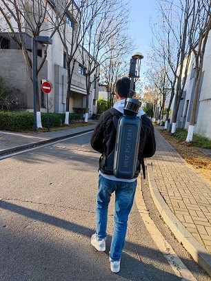
Both airborne and vehicle-mounted scanning modes have various disadvantages due to the long span and many obstructions of the facade of urban buildings. However, the SLAM technology adopted by HiSLAM laser scanner can collect all kinds of building corners, and the handheld acquisition mode can bypass all kinds of obstructions, so as to accurately measure the 3D point cloud of the facade of buildings. Its lightweight main body, intelligent measurement method and efficient point cloud processing process provide a reliable scheme for building facade reconstruction, and greatly improve the efficiency of building facade reconstruction.
Specification of 3D laser scanner HiSLAM
| Items | Parameters | 
| System Accuracy | ≤10cm(outdoor absolute accuracy) | 
| ≤10cm(indoor relative accuracy) | |
| Measurement Range | 120m@20% | 
| Scanning Point Frequency | 300,000points/s | 
| Panoramic Camera | ≥12MP | 
| Data Storage | 512GB SSD | 
| Data Transmission | GigE/USB3.0 | 
| Operation Temperature | -10-50℃ | 
| Operation Humidity | < 85% | 
| System Weight | <2.5KG(handheld host) | 
| Operation Mode | Handheld/Backpack | 
| Battery Life | ≥4h | 
Main advantages of 3D laser scanner HiSLAM
1. High reliability: high degree of productization, stable and reliable system
2. High intelligence: seamless integration of point cloud an panorama
3. High accuracy: high point cloud density, high point recognition rate, high measurement accuracy
4. Multi carrier: suitable for handheld and backpack mode
5. Integration: highly integrated, indoor and outdoor integration
|   | 
 120m Range Handheld / Backpack 3D LiDAR HiSLAM For Building Facade Measurement


                                                            120m Range Handheld / Backpack 3D LiDAR HiSLAM For Building Facade Measurement
                                                    
                        
                     10cm Accuracy HiSLAM For Urban Underground Pipe Model Construction


                                                            10cm Accuracy HiSLAM For Urban Underground Pipe Model Construction
                                                    
                        
                     300000points/s HiSLAM 3D Laser Scanner For Building Model Construction


                                                            300000points/s HiSLAM 3D Laser Scanner For Building Model Construction
                                                    
                        
                     300000points/s HiSLAM Laser Scanner For Mining Survey


                                                            300000points/s HiSLAM Laser Scanner For Mining Survey
                                                    
                        
                     10cm Accuracy 3D LiDAR HiSLAM For Earthwork Volume Calculation


                                                            10cm Accuracy 3D LiDAR HiSLAM For Earthwork Volume Calculation
                                                    
                        
                     120m Range HiSLAM LiDAR For Above Underground Space Integrated Mapping


                                                            120m Range HiSLAM LiDAR For Above Underground Space Integrated Mapping
                                                    
                        
                     Handheld 3D LiDAR HiSLAM For Interior Space Scanning And Modelling


                                                            Handheld 3D LiDAR HiSLAM For Interior Space Scanning And Modelling
                                                    
                        
                     Multi Mode 3D LiDAR HiSLAM for Forest Resource Survey


                                                            Multi Mode 3D LiDAR HiSLAM for Forest Resource Survey
                                                    
                        
                     As - Built Survey Handheld 3D LiDAR HiSLAM With 10cm Accuracy


                                                            As - Built Survey Handheld 3D LiDAR HiSLAM With 10cm Accuracy
                                                    
                        
                     120m Range Hi-SLAM 3D LiDAR SLAM High Density Mobile LiDAR Based SLAM


                                                            120m Range Hi-SLAM 3D LiDAR SLAM High Density Mobile LiDAR Based SLAM