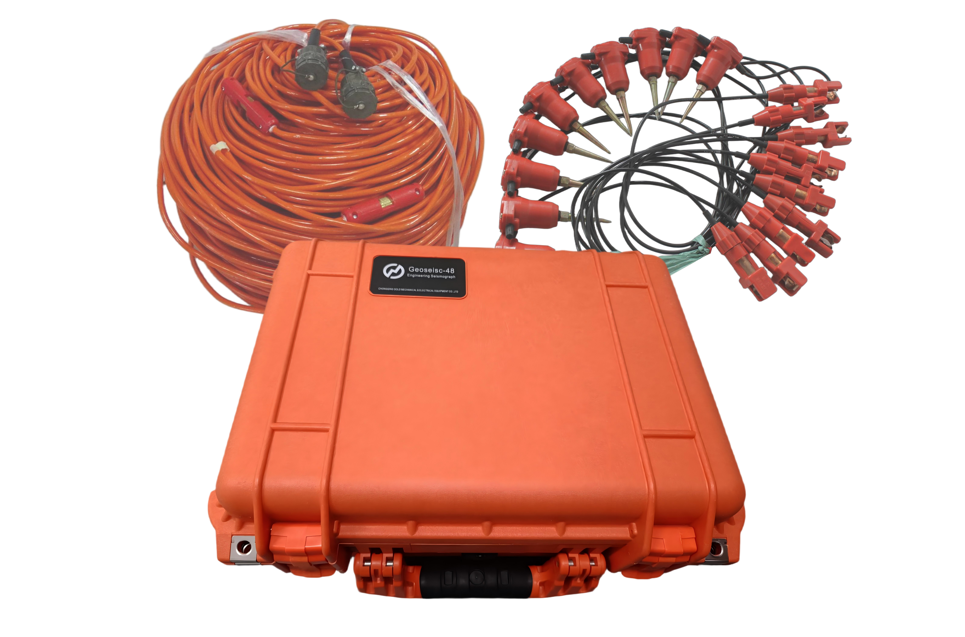
24 Channel Geophone Spreader Cable Passive Seismic Survey Cable
Every geophysical contractor knows that equipment failures cost
money. A broken Seismic Cable not only stops production but also risks losing expensive field
time. That is why we engineer our Geophone Cable and Geophysical Cable lines for maximum uptime and minimum maintenance. We produce them
in 3, 6, 12, 24, and 48 Channel versions to cover everything from small engineering studies to
large 3D surveys. The 7.2 mm outer diameter (for 32 cores) offers proven puncture and cut resistance without
making the cable too heavy for manual handling.
Connector reliability is a major factor in field productivity. That
is why we use NK-27K and 24-61 (Optional) designs. They are standard in the industry, so you can replace
them easily if needed. For the electrode takeouts, you have a clear
choice. The Muller Take-out Molded Type is the low-maintenance option; it has no exposed parts to catch on
rocks or brush. The Split Spring Take-out Ordinary Type allows rapid field repair using only basic hand tools. Both
options work with Lead-in Lengths you define (5 m, 10 m, or custom) and Interval Distances you define (5 m, 10 m, or custom spacing). And the entire assembly
is rated from -40 °C to +70°C, so you can invest in one cable family for all your climate zones.
Technical Specifications
| Specification | Description |
|---|
| Product Type | Seismic Cable / Geophone Cable / Geophysical Cable |
| Channel Quantity | 3 / 6 / 12 / 24 / 48 |
| Connector Type | NK-27K, 24-61 / Optional |
| Cable Outer Diameter | 7.2 mm (32 cores) |
| Electrode Connection | Muller Take-out Molded / Split Spring Take-out / Optional |
| Lead-in Length | 5 m / 10 m / Custom |
| Geophone Interval | 5 m / 10 m / Custom |
| Temperature Rating | -40°C to +70°C |
Comprehensive Service Support
Our company delivers more than hardware. We manufacture a complete
catalog of high-resolution geophysical instruments, including
resistivity meters, IP instruments, electrical resistivity
tomographs, magnetometers, borehole cameras, well logging systems,
and drilling equipment. Our organization includes a professional management team, a technology research, development and design team, a sales team, and an after-sale service team. This combination provides strong service support for pre-sale and in-sale work. We also provide according to your actual requirements, the most suitable
equipment and technical proposal, plus full technology consulting, training and guidance in equipment
installation, debugging and maintenance. When your instrument has an issue, you get a solution, not a
runaround.
High Resolution Technology Benefits
Our commitment to High-Resolution Seismic Exploration is not just about better plots; it is about reducing ambiguity in
your interpretations. The key technology is each channel featuring an independent 32-bit high-precision A/D
converter. This per-channel digitization removes the noise that comes from
sharing analog paths. The result is ultra-high sampling rates up to 250 kHz for sharp images of shallow structures, extremely low background noise ( ≤ 0.15 μV) for detecting subtle impedance contrasts, and an exceptionally wide dynamic range ( >140 dB) that captures both energetic first breaks and delicate later
arrivals in a single record. By ensuring precise capture of faint signals and complete preservation
of high-frequency details, we help you produce true high signal-to-noise ratio and high-resolution seismic imaging that stands up to client review.
Passive Surface Wave Survey Advantages
Active sources require fuel, permits, and safety personnel. Our Natural Source Surface Wave Exploration mode removes these costs. It uniquely incorporates natural-source
surface wave technology using microtremor and environmental noise.
Because it requires no artificial seismic sources, you benefit from safety, efficiency, zero disturbance, and zero pollution. The system rapidly inverts shear wave velocity profiles (Vs(z)) for precise stratigraphic delineation from several metres to hundreds of metres. This feature is highly cost-effective for urban shallow structure surveys and site classification, where regulatory hurdles for active
sources can be severe.
Scalable System Architecture
When your business grows, your equipment should grow with you. Our Multi-Unit Collaborative Operations allow you to link multiple instrument modules together. They
communicate via wireless ad-hoc networking technology for real-time data transmission (optional ad-hoc wireless repeater
available). Synchronisation is handled by either GPS high-precision timing synchronisation ( ≤ 1 μs) or OCXO time-keeping synchronisation (long-term drift < 0.1 ppm). This flexibility enables construction of large arrays, long lines, and distributed
observation systems without buying an entirely new seismograph. You add modules as
your project scope expands.
Intelligent Triggering System
Missed triggers mean wasted shots and repeated source points. Our Intelligent Triggering System minimizes this risk. Use physical triggering for simple hammer setups. Use time triggering for GPS-scheduled acquisition. For autonomous monitoring, engage intelligent triggering via arbitrary channel threshold level triggering (adjustable polarity and delay) or STA/LTA real-time signal self-triggering (perfect for microseismic detection). This system ensures comprehensive synchronisation, integrity, and automation of
data acquisition, so each shot is captured correctly the first time.